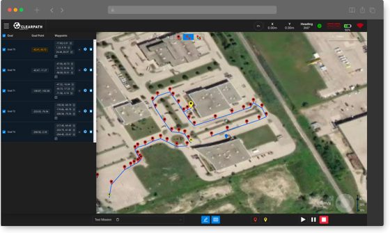
Clearpath Robotics, manufacturer of mobile robotics platforms for research and development, has launched OutdoorNav – an autonomous navigation software platform designed for vehicle developers, OEMs, and robotics researchers. Compatible with Clearpath’s outdoor mobile platforms as well as third-party industrial vehicles, OutdoorNav provides GPS-based navigation for autonomous vehicle development.
In addition, Clearpath Robotics has announced the OutdoorNav Developer Partner Program, which provides qualifying robotics developers access to discounted software licenses, and if required, hardware and sensor kits.
“Robotics product development can often be a difficult, sometimes harrowing experience,” said Bryan Webb, President of Clearpath Robotics. “Building a robust navigation system is expensive and risky, and it may prevent you from bringing your product to market in a timely fashion. We built and designed OutdoorNav to streamline your development of autonomous vehicles. You no longer need a full team of robotics navigation experts and months of prototyping to get your autonomous system into the field.”
OutdoorNav software provides point-to-point GPS-based autonomous navigation through proprietary fusion of vehicle sensor data. When paired with compatible hardware, the software also provides built-in obstacle detection and avoidance, as well as continuous path planning, allowing off-road vehicles to navigate autonomously between waypoints collision-free.
Vehicle developers can interact with the software using a web-based user interface or through a documented API. Through the web-based interface, users can create, edit, monitor and manage autonomous missions, visualize data from onboard sensors, and view the vehicle’s live position on an interactive map. Customized tasks, such as capturing sensor data or imagery at specific locations, can be easily assigned at waypoints.
The web-based interface also supports a teleoperation mode, which allows users to command and control the vehicles remotely via cellular connection using a virtual joystick. Onboard sensor data from network cameras, LiDARs, and other integrated components can be easily visualized in real-time.

